


Carbonera Valley Salento Colombia Travel Guide
- Carbonera Tour
- May 24
- 5 min read

Updated: Jun 13
The Quindío region is world-famous for its green giants, but the vast majority of travelers make the exact same mistake: limiting themselves to walking the hyper-commercialized and crowded trails of the Cocora Valley. While crowds fight for the perfect Instagram photo, just a few miles away lies an untouched, wild, and breathtaking sanctuary that holds ten times more palms. Welcome to the absolute guide to La Carbonera (Tochecito), the true premium alternative to exploring the heart of Colombia's Coffee Triangle.
Why Carbonera Valley is the Best Alternative to Cocora
To truly understand the value of La Carbonera, we have to talk about conservation. The Cocora Valley is undeniably beautiful, but it faces a severe environmental crisis: a complete lack of natural palm regeneration due to intensive cattle grazing. The palms you see there are "elderly" trees standing over artificial pasture lands.
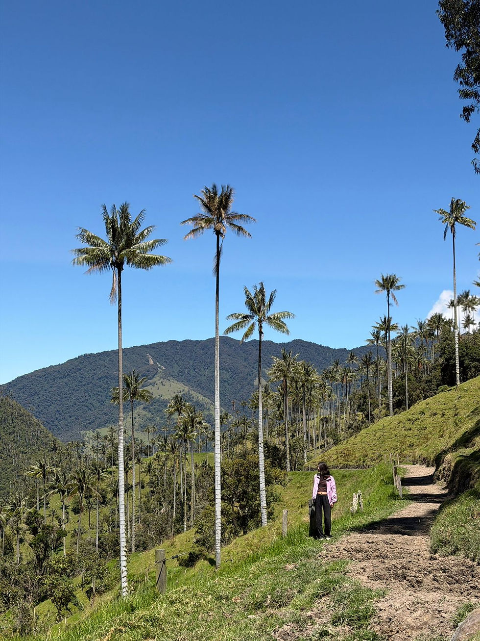
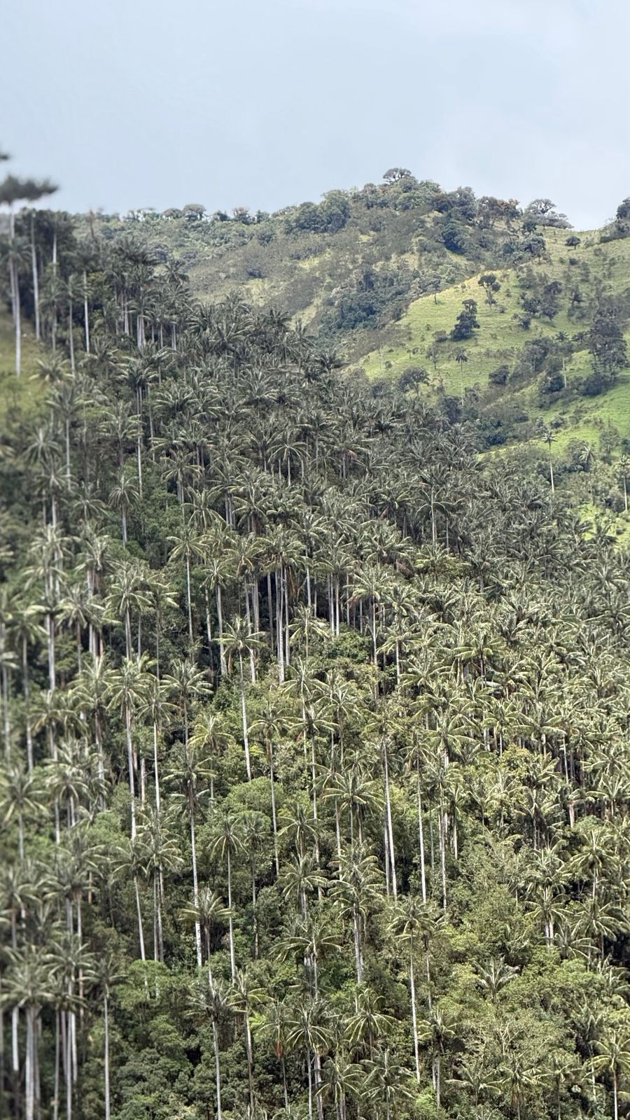
On the contrary, The Carbonera Valley, nestled in the Tochecito River basin between the departments of Quindío and Tolima, shelters approximately 80% of the world's population of the Quindío Wax Palm (Ceroxylon quindiuense), Colombia’s national tree. Here, you won't see scattered trees; you will immerse yourself in a massive green ocean—a true, dense, high-mountain native forest where baby, young, and century-old palms grow naturally in their original, undisturbed ecosystem.
www.carboneratour.com
WhatsApp: +57 3156784850
Side-by-Side Comparison: Cocora vs. La Carbonera (Tochecito)
Before packing your hiking boots, it is crucial to understand what kind of experience you are looking for. Here is a breakdown of the scenic and operational differences between both destinations:
Palm Density:
Cocora Valley: Low (~10%). Isolated, aging trees on pastures cleared for livestock grazing.
Carbonera Valley: Extreme (~90%). The densest and largest wax palm forest on the planet.
Tourist Crowds:
Cocora Valley: Massive. Hundreds of tourists daily, long lines for photos, and heavy commercial development.
Carbonera Valley: Exclusive. Practically deserted, making it a paradise for photographers and true adventurers.
Cocora Valley: Very easy. Public shared Jeeps (Willys) depart regularly from Salento's main square (20-30 minutes).
Carbonera Valley: Complex. Requires a private, high-clearance 4x4 vehicle and an experienced mountain driver (1.5 - 2 hours).
Surrounding Scenery:
Cocora Valley: Open pastures, heavily cleared cloud forests, and artificial photo props/lookouts.
Carbonera Valley: Páramo ecosystems, deep canyons, authentic heritage farms, and majestic views of Los Nevados National Natural Park.
Traveler Profile:
Cocora Valley: General tourists, large tour groups, families, and quick day-trippers.
Carbonera Valley: Ecotourists, wilderness lovers, international travelers, and landscape photography enthusiasts.
🚙 Ready to Escape the Crowds?We operate exclusive, private off-road overland expeditions in high-end 4x4 vehicles or by Willys Jeeps to Carbonera Valley with certified bilingual guides. Don't risk your safety on unpredictable high-mountain dirt roads. www.carboneratour.com
How to Get to La Carbonera from Salento: Logistics and Road Conditions
The rugged access to La Carbonera acts as a natural filter that keeps it pristine. The route follows part of the historic Camino Nacional (National Way) or Camino del Quindío—a colonial-era path once used by liberator Simón Bolívar.
The distance is roughly 22 kilometers (13.6 miles) from downtown Salento. However, due to the challenging topography and raw terrain, the journey takes between 1 hour and 45 minutes to 2 hours each way. The road is a steep, unpaved high-mountain trail prone to loose rocks, deep mud, and dramatic drop-offs.
By Rental or Regular Car: This road is absolutely not allowed nor recommended for standard cars, two-wheel-drive vehicles, or city SUVs. The risk of getting severely stuck, stranded, or damaging the transmission is extremely high.
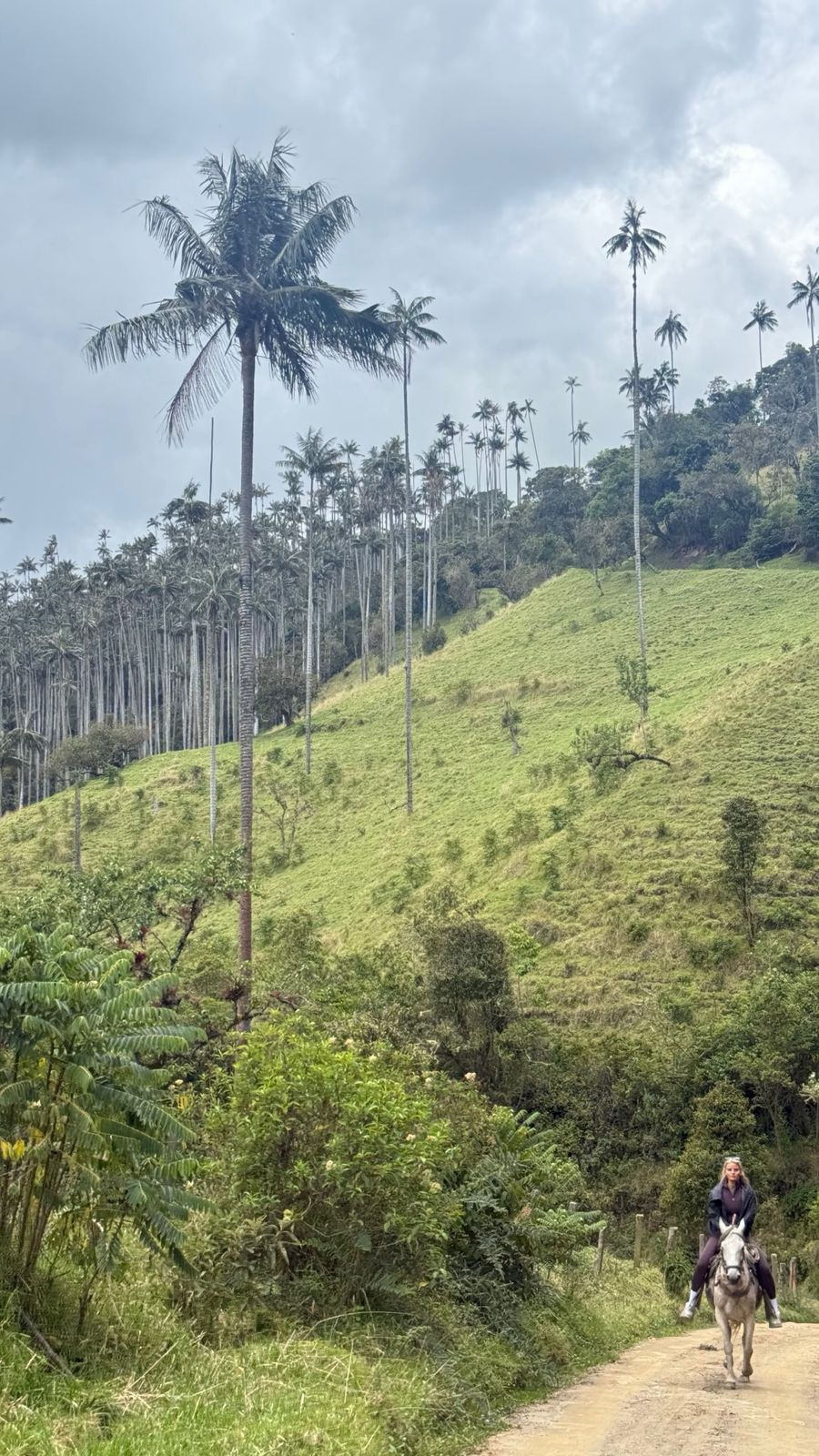
By Authorized Tour Operator (Highly Recommended): The only safe way to complete this journey is by hiring a private service using specialized 4x4 vehicles (such as Toyota Land Cruisers or heavy-duty Jeep Willys) driven by local professionals who know every single curve, mud pit, and weather trap in the Central Andes.
Recommended Full-Day Overland Itinerary
To experience the valley to the fullest, local operators design a comprehensive itinerary that perfectly blends a rugged 4x4 overland journey with gentle ecological hikes. This is the ideal schedule:
07:30 AM — Departure from Salento: Board your private 4x4 vehicle in Salento. The mountain ascent begins, showcasing abrupt changes in vegetation as the wilderness wakes up.
09:00 AM — Technical Stop at 'La Línea Alta' (3,350 msnm / 11,000 ft): The border ridge between the Quindío and Tolima regions. Weather permitting, you will catch spectacular views of the snow-capped peaks of Los Nevados National Park (Nevado del Tolima and Paramillo del Quindío).
10:00 AM — Arrival at La Carbonera & Eco-Hiking: Enter the heart of the private nature reserve. Enjoy a guided, low-difficulty hike (2 to 3 miles) surrounded by millions of wax palms stretching up to 200 feet high. This is prime time for landscape photography and birdwatching.
12:30 PM — Traditional Farm Lunch: Stop at an authentic high-mountain peasant farm to enjoy a hearty, locally sourced traditional lunch or a warm agua de panela (brown sugar cane drink) with fresh artisan cheese, directly supporting the local rural economy.
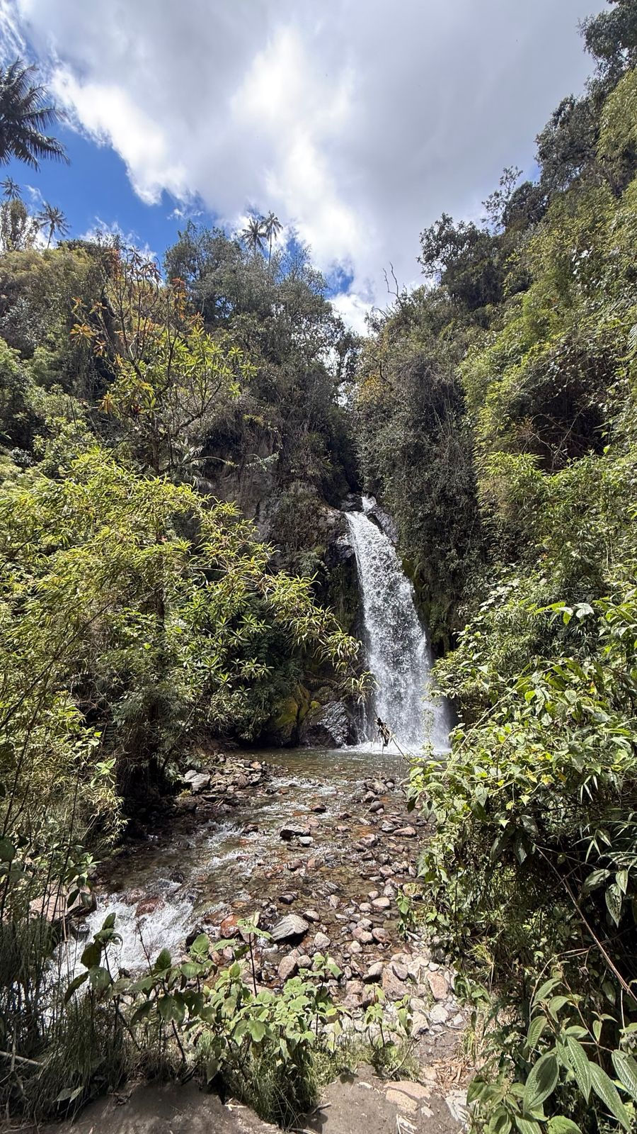
02:00 PM — Hidden Waterfall Trail & Return: A short, beautiful path leads to a pristine waterfall fed directly by the paramo glaciers. Afterward, begin the scenic 4x4 descent back to Salento.
Fauna and Flora: A Critical Biodiversity Hotspot
Unlike the highly altered landscape of Cocora, the native cloud forest of Tochecito and La Carbonera offers a vital sanctuary for critically endangered species. For wildlife enthusiasts, this area is the primary habitat of the Yellow-eared Parrot (Ognorhynchus icterotis), a bird species once thought to be extinct whose survival relies entirely on the Wax Palm, where it nests and feeds.
Additionally, while hiking through the dense undergrowth, it is possible to find signs of the endangered Spectacled Bear (Andean Bear), mountain toucans, emerald toucanets, sword-billed hummingbirds, and an endless array of wild orchids and bromeliads blanketing the tree trunks.
Carbonera Valley Frequently Asked Questions (FAQ)
When is the best time of the year to visit La Carbonera?
La Carbonera can be visited all year round. However, the dry or lower-rainfall seasons (January – February and July – August) usually offer much clearer mornings. This provides the best odds for spotting the snow-capped volcanoes and walking with less mud on the forest trails.
Is this tour suitable for children and seniors?
Yes! Because the vast majority of the distance is covered comfortably inside a private 4x4 vehicle, the walking portions inside the forest can be fully customized to the travelers' fitness levels—ranging from flat 15-minute walks to more demanding treks.
What gear and clothing are mandatory?
The weather in La Carbonera is high-alpine and highly unpredictable (temperatures can rapidly drop between 10°C and 18°C / 50°F and 64°F). It is mandatory to dress in layers, bring a windproof or waterproof jacket, wear sturdy hiking boots with excellent grip, use broad-spectrum sunscreen, and bring a hat and plenty of water.
🌿 Book Your Expedition SustainablyAt Carbonera Valley Tour, we are fully registered and licensed under Colombia's National Tourism Registry (RNT). We operate under strict environmental mitigation protocols and directly support the local peasant families of Tochecito. Enjoy true paradise without leaving a negative footprint. www.carboneratour.com WhatsApp +57 3156784850


Comments